Groundwater Observatory
Explore our field site to engage in teaching, research and collaboration opportunities
General description
This page is incomplete and needs some thinking how to best structure all these descriptions!!!
Introduction
The Institute of Groundwater Management operates a teaching and research site “Groundwater” (TRS) at the Pirna-Copitz site since 2008, which was established as part of a joint project with the Helmholtz Centre for Environmental Research (UFZ).
There are excellent conditions for innovative research and teaching as well as for establishing post-graduate training courses to strengthen (inter)national networking in the field of hydrogeology and the sustainable management of groundwater resources, the most important source of drinking water due to the already existing infrastructure and the additional infrastructure available after expansion measures,
The existing teaching and research site “Groundwater” at the Pirna site enables the implementation and practical demonstration of a wide range of established hydrogeological experiments as well as the testing of new hydrogeological methods.

Site characterisation
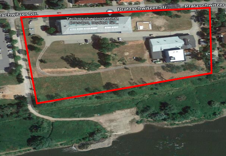
The TUD’s Groundwater Teaching and Research Observatory is part of the external TUD campus in Pirna-Copitz, about 50 meters from river Elbe. The area hosting groundwater monitoring instrumentation covers approximately 2.5 hectares (about 140 x 180 m). The terrain slopes downwards towards the river from an elevation of 119 metres above sea level to around 111 metres.
Hydrogeology
The upper quaternary unconsolidated aquifer is characterised by heterogeneous fluviatile deposits. Beneath a layer of anthropogenic fillings, highly conductive sands and gravels interspersed with silty sediments extend to depths of up to 16 metres below ground level. Further down lies a clayey-silty replacement layer from the upper Cretaceous or a low-conductivity layer (no aquifer) approximately 50-60 metres thick. Beneath this is another chalk aquifer composed of quartz/quartz sandstone, covered by an accumulating basal Plenus claystone layer. The confined conditions here are due to the existing inclination and coverage.
The groundwater level in the unconsolidated aquifer averages about 7 metres below ground and fluctuates between 4 and 10 metres. This level is strongly influenced by the Elbe water level resulting in variable groundwater flow directions. When the Elbe water level exceeds 2.5 metres (or 110.5 metres above sea level) the effluent conditions reverse, causing groundwater to flow from northeast to southwest. At the teaching and research site “Groundwater” groundwater velocities can reach up to 2 metres per hour.

Monitoring infrastructure
Some text here…
References
Scientific publications resulted from research activities conducted at the Groundwater Teaching and Research Observatory
References
Journal articles
Händel, F., Binder, M., Dietze, M., Liedl, R., & Dietrich, P. (2016). Experimental recharge by small-diameter wells: The Pirna, Saxony, case study. Environmental Earth Sciences, 75(10), 1–8. https://doi.org/10.1007/s12665-016-5701-7
Dietze, M., & Dietrich, P. (2012). Evaluation of Vertical Variations in Hydraulic Conductivity in Unconsolidated Sediments. Ground Water, 50(3), 450–456. https://doi.org/10.1111/j.1745-6584.2011.00854.x
Sallwey, J., Glass, J., & Stefan, C. (2018). Utilizing unsaturated soil zone models for assessing managed aquifer recharge. Sustainable Water Resources Management, 4(2), 383–397. https://doi.org/10.1007/s40899-018-0214-z
Glass, J., Junghanns, R., Schlick, R., & Stefan, C. (2022). The INOWAS platform: A web-based numerical groundwater modelling approach for groundwater management applications. Environmental Modelling & Software, 155, 105452. https://doi.org/10.1016/j.envsoft.2022.105452
Fichtner, T., Barquero, F., Sallwey, J., & Stefan, C. (2019). Assessing Managed Aquifer Recharge Processes under Three Physical Model Concepts. Water, 11(1), 107. https://doi.org/10.3390/w11010107
Barquero, F., Fichtner, T., & Stefan, C. (2019). Methods of In Situ Assessment of Infiltration Rate Reduction in Groundwater Recharge Basins. Water, 11(4), 784. https://doi.org/10.3390/w11040784
References
Student thesis
Bista, A. (2015). Implementation of heterogeneous high-resolution saturated groundwater flow and mass transport model for the test site Pirna for analysing multiple tracer tests [Master thesis]. Technische Universität Dresden.
Barquero, F. (2020). Infiltration capacity assessment of managed aquifer recharge spreading basins under variable climates [Dissertation]. Technische Universität Dresden.
Vanzello de Melo, J. A. (2016). Untersuchung des Einflusses verschiedener Infiltrationsszenarien auf den Wasser- und Gashaushalt, den Abbau von organischen Substanzen und die Infiltrationskapazität in der ungesättigten Bodenzone [Master thesis]. Technische Universität Dresden.
Brecht, S. (2015). Abschätzung der Grundwasserneubildung mit Hilfe eines Tracerversuches in Pirna, Deutschland [Master Thesis]. Technische Universität Dresden.
Li, C. (2014). Conception of a high-resolution saturated model for the test site Pirna [Master Thesis]. Technische Universität Dresden.
Moreno, M. (2015). Methods for characterization of soil hydraulic properties and sub-surface stratigraphy with application at an infiltration site in Pirna, Germany [Master thesis]. Technische Universität Dresden.